History
OVERVIEW
The Naval Air Station (NAS) was identified for closure in 1992, and officially listed in 1993:
- 1993-1996: A Base Reuse Advisory Group, consisting of Bay Area officials and residents, put together a community base reuse plan, which established a framework for future development with the primary focus on replacing the 16,000 lost jobs. (NAS closed in 1997)
- 1996 to present: The Navy identified toxic sites and began clean-up efforts overseen by: 1) three regulatory agencies (US EPA, CA EPA Dept. of Toxic Substances Control, and regional water quality authority); 2) a city-hired consultant (Peter Russell); and 3) the community restoration advisory board (RAB). Most cleanup activities fall under superfund law known as the Comprehensive Environmental Response, Compensation, and Liability Act (CERCLA). The petroleum program cleanup is separate, as is the cleanup of radiological contamination inside of buildings.
- 1999: A draft EIR was issued that included 2,000 housing units.
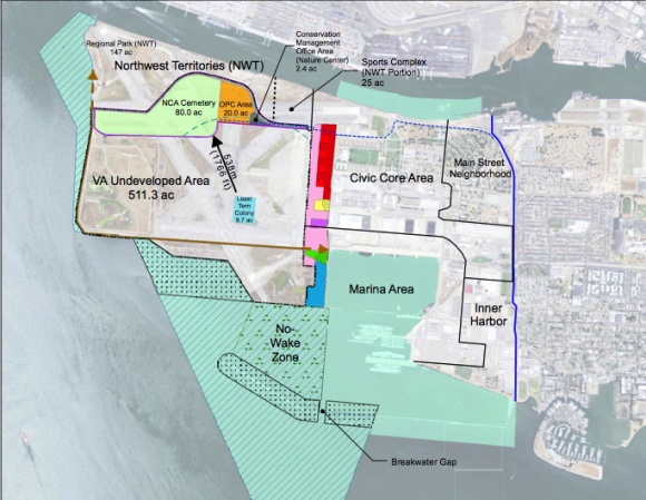
- 2004: The US Fish & Wildlife Service (F&W), which had planned to run a wildlife refuge, reached an impasse with Navy due to liability over the toxic landfill (site 2). The Navy enlisted the Veterans Administration (VA) to take over land, but the endangered least tern colony will always be under control of the F&W though. The VA’s undeveloped land (511 acres) has hosted 187 species, and 23 species of birds have been documented breeding there.
- 2000-2010: The city unsuccessfully attempted to develop NAS two times with master a developer: 1) in 2006 Alameda Point Community Partners (APCP) dropped out when the Navy decided to charge $108 million for the land; 2) in 2010 SunCal was rejected by referendum at the ballot box by 85% margin due to a bad business deal and concerns over housing density (4,800 units).
- 2011: The Navy returned to a no-cost conveyance with original condition of building 1,425 housing units with focus on job creation. (Original minus Bayport & Shinsei Gardens housing developments) The agreement contained a disincentive for going over limit; each additional market-rate home will cost an extra $50,000 paid to the Navy.
- 2013: The City of Alameda took title to about 1,400 acres of land and water from the Navy on June 4, 2013. It was the first, and largest, phase of land transfer to the city since the Naval Air Station closed in 1997. The base was listed for closure in 1993.
- 2014: The U.S. Department of Veterans Affairs (VA) took title to 624 acres of land from the Navy at a ceremony on November 3, 2014. The VA will construct an outpatient clinic and columbarium on 112 acres, with the remaining 512 acres remaining undeveloped.
- 2016: The City of Alameda took title to another 183 acres of land and water from the Navy on April 13, 2016. The Phase 2 land transfer consists of 37 acres of dry land and 146 acres of water. The Seaplane Lagoon covers about 110 acres, with the remainder being in the adjacent deepwater port. Less than 100 acres remains to be transferred to the city in two more phases expect to be completed by 2021.
Present Situation
- 75% of cleanup is near completion but the Navy is legally responsible for any toxics that re-appear on official cleanup sites on city land in perpetuity.
- The NAS Alameda Historic District contains 90+ buildings up for preservation.
- The Navy conveyed about 40% of land to Veterans Administration on June 27, 2014, and 60% to the city in phases based on cleanup, starting in mid-2013.
- The city has decided to act as master developer, creating its own master infrastructure plan, town center plan, zoning proposal, and EIR, and to sell off parcels. Consistent with reuse plan, area will include about 5.5 million square feet of employment uses; 1,425 residential units, including 260 existing single family and multifamily housing units, with 25 percent affordable; 258 acres parks and open space, including Bay Trail. Goal for completion 2035.
- City opted to forego receiving 74 acres (hump on map) of its Northwest Territories from the Navy in order for the VA’s project to be built further away from the nesting area for the endangered least tern colony. The city, in February 2014, removed the "regional park" designation on the remainder of the Northwest Territories for reasons unexplained.
Environmental Review
- The city conducted its environmental review process under the California Environmental Quality Act (CEQA), with its “baseline” project matching that of the Navy's conditional no-cost conveyance (1,425 homes). In February 2014, the Alameda Point environmental impactrReport was certified, along with a zoning ordinance and infrastructure plan. See Final Planning Documents
- The city endorsed a resolution to zone the VA undeveloped land as a Nature Reserve on March 19, 2013.
- The U.S. Department of Veterans Affairs (VA) final environmental assessment (EA) under the National Environmental Policy Act (NEPA) was approved in December 2013. See VA Planning Documents
- The San Francisco Bay Conservation and Development Commission (BCDC) certified the VA project as being consistent with California laws, and included certain public access stipulations in its approval in January 2014. See Minutes of BCDC Meeting, Agenda Item 9.
- The city adopted the Town Center and Waterfront Specific Plan for the area around the Seaplane Lagoon in July 2014. See Town Center/Waterfront Plan